Flights near airports
When operating unmanned aircraft in or near the airfields of Vilnius, Kaunas, or Palanga, additional requirements must be followed. Applications for planned unmanned aircraft system (hereinafter “UAS”) flights within an aerodrome’s flight control zone above the vertical boundaries of designated UAS geographic zones are evaluated and decisions are made by the air traffic service provider AB “Oro navigacija.”
If an unmanned aircraft operator plans to conduct flights within the territories of the Vilnius, Kaunas, or Palanga aerodromes or in their vicinity, additional approval from the aerodrome operator is required.
How do I get approval?
- The application must be submitted no later than 3 business days before the planned flight.
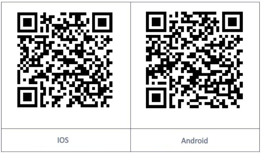
- The map is available as an app for Android and iOS users. Search for “Lithuania Drone Map” in the Google Play or App Store to find the app published by Oro navigacija. You can also scan the QR code below.
Unmanned Aircraft Traffic Management System utm.ans.lt
The UTM system (utm.ans.lt) is a digital platform designed to plan, register, coordinate, and manage unmanned aircraft (UAV) flights in very low airspace. It helps ensure that flights are conducted safely and in compliance with regulations.
By using the system, you will be able to:
- view the geozones that will be crossed during the planned flight;
- determine whether a permit is required in a specific zone;
- submit flight plans and applications directly to the authorities;
- ensure transparent cooperation with the relevant agencies.
The UTM system helps prevent regulatory violations, reduces the administrative burden, and enables faster flight planning.
How does the system work?
Currently, the UTM system applies only to those parts of airspace where flights do not require additional permits – primarily in uncontrolled airspace and within CTR zones up to specified minimum altitudes. In such areas, operators can plan and declare their flights directly through the system, in compliance with EU and national legislation.
If the planned flight involves restricted areas or military zones, the standard permit issuance procedure applies—applications must be submitted in advance by the specified deadlines.
What’s next?
Currently, the system covers only those parts of the airspace where flights are permitted without a separate authorization. However, there are plans to begin issuing authorizations directly through the UTM platform in the near future – system users will be the first to learn about this new feature.
Geographic zones for unmanned aircraft
What is a geographical zone, and what types are there?
Geographical zones for unmanned aircraft (geozones) are specific segments of Lithuanian airspace in which special restrictions or requirements have been established to ensure the safety and privacy of civil aviation, military and strategic facilities, and the public.
Types of geozones according to the EU Regulation and the Law on Aviation of the Republic of Lithuania
Prohibited – a geographical zone where all UAS flights are prohibited, except in cases where the geozone administrator grants permission in accordance with its established procedures.
Restricted – a geographical zone in which restrictions are imposed regarding administrative procedures, operational limitations, technical UAS requirements, or mandatory UAS functions (flight altitude, UAS weight, UAS aircraft class).
Special operations – a geographical zone in which one or more of the open category requirements may not apply.
U-Space – a geographical zone in which flights are conducted in accordance with the requirements set forth in European Commission Regulation (EU) 2021/664.
No airspace risk assessment is required to establish prohibited and restricted geographic zones. A risk assessment conducted by the Transport Competence Agency is required to establish special operations and U-Space zones.
Who can establish geographical zones and on what basis?
The Lithuanian Transport Safety Administration (the Administration) is responsible for establishing geographical zones for unmanned aircraft systems (UAS) pursuant to Article 18(5) of the Law on Aviation of the Republic of Lithuania.
Geographical zones over military territories and within a radius of no more than 2 km around these territories, as well as in the border zone, are established by the Commander of the Armed Forces in accordance with his established procedure, after consultation with the LTSA.
National defense system institutions, intelligence agencies, the Command Protection Service, and statutory institutions have the right to establish temporary prohibited or restricted geographical zones for unmanned aircraft systems (UAS).
How do you know where the geozones are?
All geographical zones approved by the LTSA and the Commander of the Armed Forces are published on the UTM platform.
Restricted Areas
Restricted zones are areas of airspace where UAV flights are strictly prohibited, unless a special permit has been obtained from the competent authority.
These zones are established to ensure national and public security, protect military infrastructure, strategic (e.g., infrastructure, energy) or other facilities, and aviation safety near aerodromes of special importance.
Possible designations: UP, T, EYP, BRDR
Important for BO users:
- Flights without a permit are prohibited, regardless of the type of aircraft or flight altitude.
- Permits are granted on an exceptional basis and are evaluated on a case-by-case basis.
- Violations may result in criminal or administrative liability.
For example, geo zones may include military bases or other facilities, nuclear and strategic infrastructure facilities, the Presidential Palace, the Seimas, and other protected facilities of national importance, as well as border areas along the state border of the Republic of Lithuania where UAV flights are prohibited for reasons of national security.
Other areas
Danger Area (Danger Area)
Danger zones are parts of airspace where activities that pose a danger to unmanned aircraft (UAV) flights may take place, such as military exercises, firing ranges, explosions, experimental tests, or other high-risk operations.
Possible designations: EYD
Temporary Segregated Area
This is a temporary special zone established for a specific period and purpose (e.g., exercises, special flights, tests). When an EYTSA is active, the airspace is reserved exclusively for that user, so others (including drones) are prohibited from flying there.
When inactive, the zone does not exist—flying is permitted under general rules.
Possible designations: EYTSA
Flights of unmanned aircraft in controlled airspace
To operate an unmanned aircraft (UA) within the vertical boundaries of designated geographical zones in an aerodrome control zone, one must first hold an STS remote pilot certificate issued by the Transport Competence Agency, and, if applicable, a permit to conduct special category flights. Flights over Vilnius, Kaunas, and Palanga airports (Zone 0) require a permit from the airport operator, which is issued through the UTM system. Flights in the zero zone of Šiauliai Airport additionally require permission from the airport operator and the commander of the LK KOP Aviation Base, which must be obtained separately and sent by email to bepiloč[email protected]. Without these documents, flights in this airspace are prohibited.
All flight applications must be submitted via the UTM system (the website utm.ans.lt or the mobile app Lithuania Drone Map). The application must include the contact information of the user and the remote pilot, two mobile phone numbers*, the planned flight time, location, and altitude. If flights are planned for several days, a separate application must be submitted for each day.
A flight request submitted in the UTM system is coordinated electronically; however, its confirmation does not constitute authorization to conduct the flight.
On the day of the flight, the pilot must submit a request for takeoff clearance in the UTM system (by clicking the “Request Takeoff Clearance” button) at least 30 minutes before the flight and notify the Flight Operations Center by phone of the intention to conduct the flight. The flight control center’s contact information will be sent to the flight applicant via a message in the UTM system or to the specified email address. The flight may only be conducted after receiving final clearance from the flight control center. Throughout the entire flight, the pilot must maintain contact with the flight control center and follow all of its instructions. Upon receiving an instruction, the flight must be immediately adjusted or terminated.
Upon completion of the flight, no later than 5 minutes after landing, the pilot must mark the end of the flight in the UTM system (by clicking “End Flight”) and notify the flight control center by phone.
Flights may be restricted or prohibited depending on air traffic volume or weather conditions.
*Under current procedures, the remote pilot must provide two phone numbers that can be used to contact them in case of an emergency. The second phone number should be entered after the first one, with a space in between. Do not include any other characters (commas, periods, or hyphens).
Useful links
Geozones – Geographical Zones for Unmanned Aircraft Operations in Europe
VFR Air Navigation Chart (Online)
Lithuanian System of Geographical Zones and General Information Services for Unmanned Aircraft
Lithuanian Transport Safety Administration (Unmanned Aircraft)
Transport Competence Agency (unmanned aircraft)
On the Approval of the Procedure for Conducting Unmanned Aircraft Flights Above the Vertical Limits of Designated Unmanned Aircraft System Geographical Zones in Controlled Airspace
Do you have any questions? Please contact us
For inquiries regarding unmanned aircraft, please email [email protected] at any time. During business hours (7:30 a.m. to 4:15 p.m., Fridays until 3:00 p.m., and on days before public holidays until 3:15 p.m.), please call +370 706 94 537.
FAQ
What is a restricted zone (P)?
An area where flying a drone is strictly prohibited, such as military zones or strategic sites.
Tip: You cannot fly a drone without special permission. Information about zones and flight conditions can be found on the unmanned aircraft map at utm.ans.lt or in the Lithuania Drone Map mobile app.
What is a restricted zone (R)?
An area where flying is permitted but subject to certain restrictions, such as limited altitude, a specific distance from objects, or permission from the responsible authority.
Check the map at utm.ans.lt or the Lithuania Drone Map app before flying.
Is it possible to fly within an airport’s territory with only an A1/A3 license?
No. Even with an A1/A3 license, flying in the Control Zone (CTR) is prohibited. An STS license and permission from the Airport and Air Navigation Services are required.
How can I find out if flying is permitted in a specific location?
Check utm.ans.lt or the Lithuania Drone Map, which shows prohibited, restricted, and temporarily restricted zones.
Does an A1/A3 license allow you to fly in restricted areas?
No. In restricted and limited-access areas, you need permission from the relevant authorities, regardless of your license.
What is a temporarily restricted zone?
An area where flights are restricted for a limited time, for example, due to events, VIP flights, or air shows.
Check utm.ans.lt or the Lithuania Drone Map—zones may be active only for a limited time and at specific altitudes.
Can I fly a drone near people or buildings?
In the A1/A3 category, you may fly over people only with very light drones (<250 g). Larger drones may not fly over groups of people or buildings without permission.
How can I find out the altitude limits for prohibited and restricted zones?
The map at utm.ans.lt and the Lithuania Drone Map app indicate vertical limits—the maximum altitude at which you can fly without additional permits.